Case Study: Neighbourgood Responsive Website and Mobile App
The Product.
A responsive companion website to a dedicated mobile app of the same purpose. The Duration, January 2022-July 2022. Create a product that allows communities to search and find new park locations and opportunities for outreach. The results will help us to determine what features would make this product more useful and the experience of finding park/outreach opportunity locations from start to finish.
Project Overview
-
The goal of this project was to create a product that will allow people and entire communities to find suitable locations for parks and other public spaces for various funct
Goal
-
The challenge was to create a companion website that was consistent with the look and feel of the dedicated mobile app, as well as adapt to cross platform screen sizes.
Problem
-
Lead UX designer, UX researcher, Visual and Interaction designer. Responsibilities include (but not limited to) user research, problem defining, wireframing, prototyping, testing, visual and motion design.
My Role and Responsibility
User Research
Goal
Find locations that are accessible and can accommodate gardening and social spaces for the elderly.
Problem Statement
Barbara is a retired horticulturalist who would like to find a location that will accommodate her peer groups access to nature and away from the overcrowding and noise of local parks.
Frustrations
Overcrowding, turbidity , noise lack of available spaces.
-

Barbara Goode
Age: 77
Education: High School
Occupation: Retired horticulturalist
Family: 2 feisty cats 😹
Hometown: Savannah, GA.
Barb is a retired horticulturalist who is currently head of events in her communities assisted living facility. She would like a service that would allow her to search and locate adequate and accessible park spaces for her outdoor peer group activities based on a criteria. Including gardening, fitness and social gatherings.
"The local parks are overcrowded. They do not accommodate elderly visitors. The Traffic and pollution are also dangerous for my groups age." -Barb
-

Andres Pacheco
Age: 37
Education: College Grad
Hometown: Salem, Oregon
Family: Girlfriend, 2 dogs
Occupation: Survivalist Trainer
Andres, his girlfriend and dog enjoy being outdoors. As a survivalist and nature educator, Andres enjoys immersing the youth in his community into as much wilderness as possible for better hands on survival training, teaching them about flora and fauna.
“I’d like to give my students in my community a well rounded education in nature, but I can’t find adequate places.” -Andres
Barbara’s Journey(worst case)
Goal: Find open, accessible safe locations for new parks with amenities specific to the elderly community and group.
Goal
Find adequate park locations for survival training and environmental education.
Problem Statement
Andres is a community survivalist who needs nature space to educate the community youth because current public spaces do not have the materials needed to teach his skills.
Frustrations
Cannot find suitable locations with biodiversity in order to educate youth in the field.
Goal: Find open, accessible safe locations for new parks with amenities specific to the elderly community and group
Andres’ journey(best case)
1st Half of the audit.
Ideation
Competitive Audit
This ideation method included researching any competitors in the space to find this particular service, how it was implemented and find any missed opportunities. My goals were to review competitor sites UX and find ways to scale and make accessible to the next billion users.
2nd Half of the audit.
Crazy 8’s
Crazy 8’s sketching was used to progressively iterate design elements in order to maximize as much accessible relevant information as possible on multiple platforms .
Mobile Homepage
Search Results Mobile
The First Design Iteration
Digital Wireframes
The idea here is to design a product/service that will allow the user to find adequate open space locations(or potential spaces) after a number of choices are made to get as close to an ideal location as possible(where available) and so initially I thought using a map application style interaction as the most familiar interface for location and travels searches.
Tablet Homepage
Search Results Tablet
Desktop Homepage
Search Results Desktop
These prototypes represent different breakpoints demonstrating a user searching for open space locations using the data visualization interaction idiom to view data associated with a location and set of criteria.
Lo-fidelity Prototypes
Users will start with a localized map and begin their contextual search using the “+” action button for either an address, zip code, general municipalities.
Once a location is chosen the user is given filters to use in order to narrows the results to more relevant locations that will meet the users needs.
Usability Studies
Study Type: Unmoderated Usability Study
Location: Remote
Participants: 7
Length: 30 - 60 minutes
Usability Study: Insights
More data, specifically related to crime, zoning, environmental and more detailed demographic data of the neighborhoods and communities of these locations.
Users wanted options that filtered more versatile locations that allow more ideas and different events for the locations.
Next step information and guides that provide information on how processes that will help them secure these spaces for their purposes, as well as allowing communities to organize and participate.
Refining the Design
1.Mock-ups
2.Hi-Fidelity Prototype
3.Accessibility
Mock-ups
The initial mock-ups used a navigation style interaction design with a localized map and an F.A.B. as the entry point for finding new places right from the homepage.
Initial Designs

Environmental information is gathered and added from databases. This additional information is identified through labeled icons
Desktop - 1440 x 1024
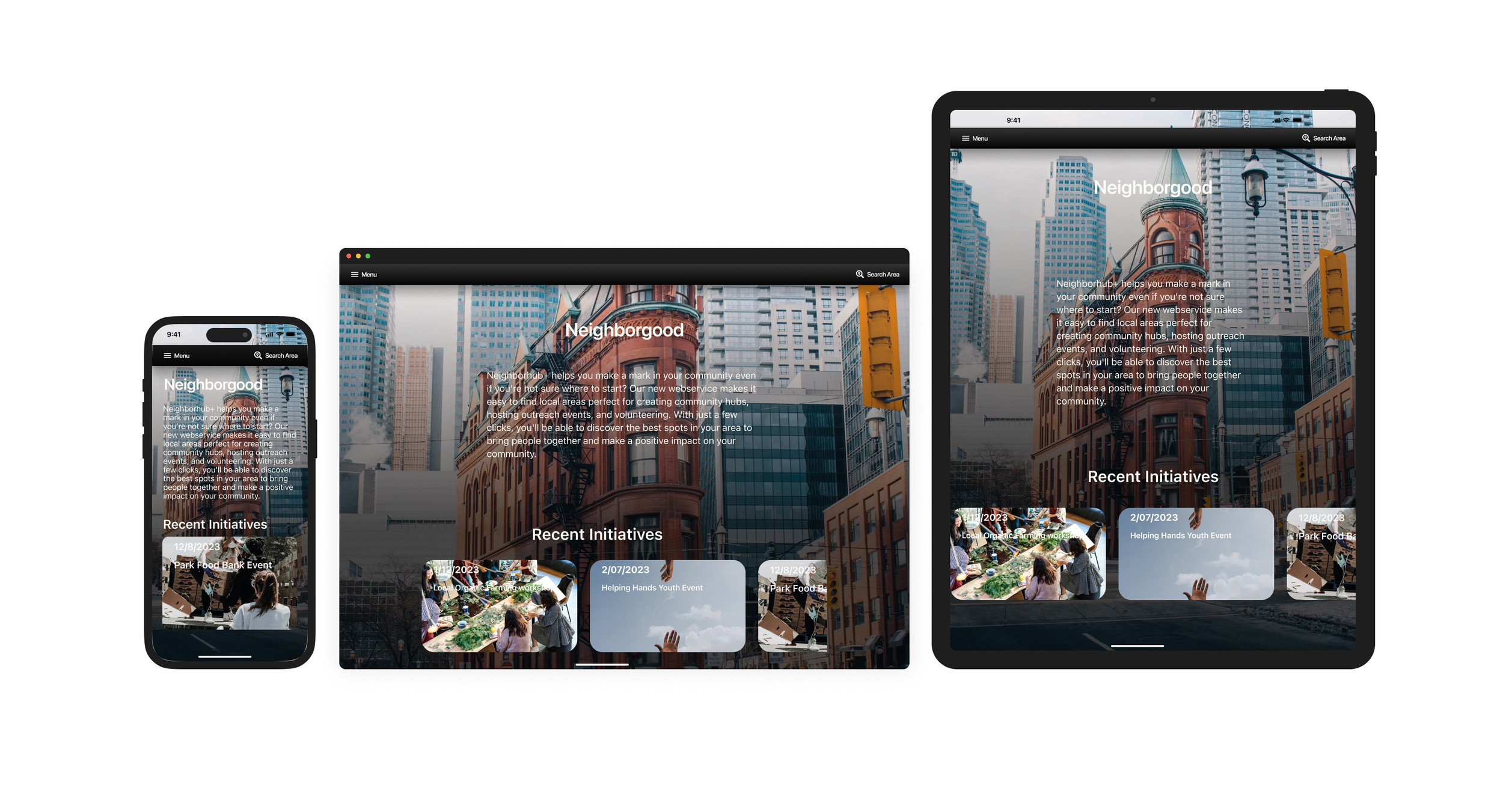
Final Designs
The Final mock-up provides an introduction and brief explanation to the product and service as well as any available local places, groups or initiatives on the homepage as well as providing a menu for additional features, services and information.

Mobile - iphone 14 Pro
Additional information includes links local zoning, demographic, weather databases.
Tablet - iPad 12.9"
Landscape
Going Forward
Take aways
Impact
Updates made to the design after user feedback improved overall usability of the website. Users where able to search and find results that were closer to the results they were expecting from this type of service.
What was learned?
With this product iteration having a larger assortment of options to choose from each category of questions made the service more inclusive for a wider range of public space scenarios. Among those choices are accessibility considerations, amenities etc. were appreciated and gave users more complete and narrow search results when looking for public space locations.
Next Steps
1
Continue additional redesigns based on user Feedback.
2
I will add more motion design and micro interactions to engage user focus and signal actions.
3
Include additional accessibility features to make the site more inclusive for people with disabilities.